Pico Arieiro Bike Climb - PJAMM Cycling

48
PDI
11.2 mi
DISTANCE
5,819 ft
GAINED
9.8 %
AVG. GRADE

FULL CLIMB STATS

Page Contributor(s): Ard Oostra, Switzerland; Helmuth Dekkers, Netherlands

INTRO

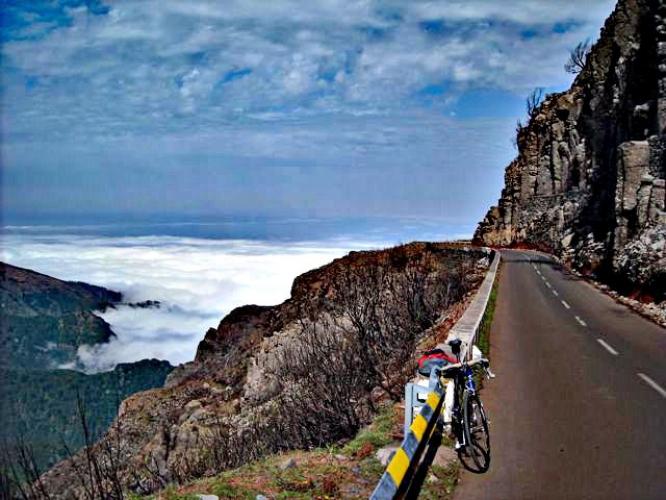
Pico Arieiro is the most difficult bike climb in Portugal and one of the Top 20 in the world.  The views from the top area above the clouds are spectacular - similar to the view from the top of Mauna Kea.  The crux of this climb is at the start - the first 2.6 km average 20%.  

PLAN YOUR ROUTE

We've partnered with Sherpa-Map.com to bring you the best route planning tool. With a PRO Membership you can use this climb as a reference when creating your route.
Average grade is 9.8% (10.8% if descent is removed from the gradient equation!).  While 7% of the ride is descent, a daunting 11% is at 15-20% and another 11% is at ≥20%.  The steepest 500 meters is 24% and there is a two kilometer segment that averages 22%!!  

See more details and tools regarding this climb's grade via the “Profile Tool” button.
Roadway:  Narrow two lane road with center stripe for the first 3.5 kilometers through densely populated Funchal.  Once you leave the city behind, the road is bordered initially with tropical foliage and flowers for several kilometers until we enter a forested section for about five kilometers beginning at kilometer 9.4.  From kilometer 12 to the top, we have unobstructed views of the volcano and ocean or the clouds we have ridden above.  All the while the roadway is two lanes with a center stripe and in excellent condition. 

Traffic:  Mild to moderate for the first four kilometers and mild thereafter.

Parking:  There are a couple of parking garages near the climb start (MapStreet View), address - 87 Rua 5 de Outubro Funchal, Madeira. Also see Google Map - Parking in Funchal.
Provisions:  There are several restaurants on the climb and a cafeteria at the complex at the top of the climb. 
Before heading out on any cycling adventure check out our Things to Bring on a Cycling Trip and use our interactive check list to ensure you don't forget anything.
The views at the top of the climb are spectacular - see, Google - Viewpoint Pico do Areeiro + Reviews.  The Pico do Arieeiro to Pico Ruivo is a highly rated difficult hike: 6.7 miles out and back with 3,871' of elevation gain.  The terrain, scenery, and colors at the top of this climb remind us a bit of Waimea Canyon - Kokee Road.  Also be sure to walk up the steps to PR1 Vereda do Areeiro for magnificent views (Google Map + Reviews).  

Use the “Routes in Area” button on the menu bar to see other bike climbs in this area.

ROUTE MAP

MEMBER RATING

Not Yet Rated
-
Road
-
Traffic
-
Scenery

CURRENT WEATHER

PJAMM TRIPS ADVENTURE STARTER BUNDLES

Check out PJAMM Adventure's prepackaged (self-guided) cycling trips. They will help you plan, document and conquer your next adventure.
ALL TRIPS
Browse all of our prepackaged trips and find your next adventure!

NEARBY CLIMBS (0) RADIAL PROXIMITY

FROM
No Climbs Found

MEMBER REVIEWS & COMMENTS

Let us know what you thought of this climb. Signup for our FREE membership to write a review or post a comment.
Already have an account?
ROUTE MAP
PROFILE TOOL
Route Data
S.G. (%)
hide
Segment Data
hide
CLIMB SUMMARY

Climb Summary

Pico do Arieiro - Wikipedia 

Photo:  Bjørn Christian Tørrissen

Ride 18 kilometers gaining 1,776 meters at an astonishing 9.8% average grade.

This is the most difficult bike climb in Portugal and one of the Top 20 in the world.  

Of this ride, Wikipedia notes:

“Pico do Arieiro, at 1,818 m (5,965 ft) high, is Madeira island's third highest peak.  Most days, visitors can stand and look down on the clouds. The air is fresh and clear and the sun is very bright. On a clear day it is possible to see the neighbouring island of Porto Santo, 30 miles to the northeast.

The footpath northwards towards Pico Ruivo is an important tourist attraction, with a daily average of 1000 tourists trekking on it.

There is easy road access to the summit, with a large car park, a restaurant and souvenir shop. In 2011, an Air Defence Radar Station was built at the top of the mountain near the tourist facilities.”